- Home Page /
- Sports Outdoor & Fitness /
- Hunting & Fishing /
- Fishing /
- Tools /
- Charts & Maps /
- UKHO BA Chart 1967: England a South Coast, Pl...
0 ratings

Item #:
124546194
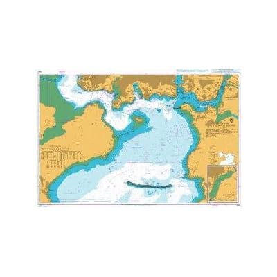
UKHO BA Chart 1967: England a South Coast, Plymouth Sound. River Plym
Item #:
124546194
SLL 1805011
Price Details
Excluding Shipping & Custom charges ( Shipping and custom charges will be calculated on checkout )
*All items will import from US
0 ratings
Write a review
In stock
QTY:
Order now and get it around Tuesday, July 14
Secured transaction
Ubuy works hard to protect your security and privacy. Our advanced payment security system ensures confidentiality by encrypting your information during transmission using AES (Advanced Encryption Standards) and SSL (Secure Socket Layer) protocols. Your payment details are 100% secure as we do not share your payment details with third party sellers.
Our Top Logistics Partners
Admiralty standard nautical charts comply with Safety of Life at Sea (SOLAS) regulations and are ideal for professional, commercial and recreational use.
Fast
Shipping
Free
Return*
Secure Packaging
100% Original Products
PCI DSS Compliance

ISO 27001 Certified
Note: Step Down Voltage Transformer required for using electronics products of US store (110-120). Recommended power converters Buy Now.


What Stands Out
Detailed Navigation Data
Provides comprehensive navigational details for Plymouth Sound and River Plym, ensuring mariners can safely navigate through complex waters with clarity and confidence.
High-Quality Cartography
Utilizes superior cartographic standards for enhanced readability and precision, making it easy for users to interpret marine environments and avoid hazards.
Reliable Updates
Regular updates ensure the chart reflects the latest navigational changes, offering peace of mind to users and maintaining maritime safety in busy coastal areas.
Product Details
| Item Weight | 0.5 lbs (230 grams) |
Who Should Buy?

-
Professional Mariners
Ideal for professional sailors and seafaring individuals needing accurate navigation charts of Plymouth Sound and River Plym.
-
Marine Enthusiasts
Perfect for boating enthusiasts and hobbyists who enjoy exploring the waters around Plymouth and its coastline.
-
Local Fishermen
Useful for fishermen requiring detailed charts for safe navigation in the Plymouth Sound area for effective fishing routes.

-
Inexperienced Users
Not suitable for those lacking navigation skills, as it requires understanding of maritime navigation and chart reading.
-
Recreational Paddlers
Less useful for recreational paddlers or casual users who do not need detailed navigational information for small craft.
-
Land-based Activities
Individuals focused on land activities or inland navigation will find this marine chart irrelevant and unnecessary.
Product Description
UKHO BA Chart 1967: England a South Coast, Plymouth Sound. River Plym
Have any Query? Chat with us
Customer Questions & Answers
-
Question:
What information can I find on the BA Chart 1967 for Plymouth Sound and River Plym?
Answer: The BA Chart 1967 for Plymouth Sound and the River Plym provides essential navigational information, including topography, buoys, hazards, and other maritime details crucial for safe navigation. This chart is particularly useful for sailors and marine enthusiasts who navigate these waters, as it helps in identifying safe passage routes and potential dangers in the area. The chart’s detailed portrayal of features like harbors, depths, and landmarks enhances situational awareness, making it an indispensable tool for both recreational and commercial boaters. -
Question:
Is the BA Chart 1967 suitable for both recreational and commercial boating?
Answer: Yes, the BA Chart 1967 is suitable for both recreational and commercial boating. Its comprehensive data allows recreational sailors to plan enjoyable outings while ensuring safety, while commercial operators rely on its accuracy for efficient navigation in busy waters. Boaters will find this chart useful for route planning, ensuring they can quickly adjust their paths based on navigational hazards or changing tides, thus facilitating safer and more strategic vessel operation. -
Question:
How do I interpret the symbols and markings on the BA Chart?
Answer: Understanding the symbols and markings on the BA Chart 1967 is crucial for effective navigation. Each symbol represents specific features, such as buoys, hazards, depth markings, and navigational channels. The accompanying legend typically explains what each symbol signifies. By familiarizing yourself with these symbols, you increase your ability to navigate safely and efficiently, whether you're plotting a course or making adjustments while on the water. -
Question:
Is the BA Chart 1967 updated regularly to reflect changes in navigation?
Answer: BA Charts are periodically updated to ensure they reflect the latest navigational information and changes in the waterways. While the 1967 edition provides a historical perspective, it's important to consult with relevant maritime authorities or updated resources to verify current conditions. Navigators often cross-reference with newer data to confirm their route, ensuring they avoid any outdated or inaccurate information that may compromise safety during their journeys. -
Question:
Can I use the BA Chart 1967 for digital navigation systems?
Answer: The BA Chart 1967 is primarily a physical chart, but many modern navigation systems allow for scanned copies of traditional charts to be integrated digitally. When utilizing a digital navigation system, check if the application supports overlays or imports of such historic charts. This compatibility can enhance your navigational methods by combining traditional knowledge with modern technology, providing a comprehensive view of your nautical environment. -
Question:
Are there specific recommendations for using the BA Chart 1967 in adverse weather conditions?
Answer: When using the BA Chart 1967 in adverse weather conditions, it's crucial to exercise heightened caution. Review the chart to identify safe havens or sheltered routes, and stay updated on weather forecasts. Mariners should have contingency plans in place, which may include alternative routes or safe zones based on the chart’s features. This preparation helps manage risks associated with sudden weather changes, contributing to a safer boating experience. -
Question:
What tools do I need to effectively use the BA Chart 1967?
Answer: To effectively use the BA Chart 1967, you'll need navigation tools like a compass, vernier caliper, and perhaps parallel rulers or a plotter. A detailed logbook for tracking your routes and conditions encountered is also recommended. With these tools, mariners can accurately plot their courses, determine distances, and monitor their progress, ensuring they navigate the waters safely and efficiently. -
Question:
Where is the best place to view and utilize the BA Chart 1967 while boating?
Answer: The best place to utilize the BA Chart 1967 while boating is in a designated navigation area on your vessel where you have a stable surface to consult it easily. Ensure that your viewing area is sheltered from elements, allowing you to adjust your position accurately and make relevant notes. Some boaters prefer to laminate their charts to protect them from water and wear, ensuring they remain intact and usable throughout their journey. -
Question:
What makes the BA Chart 1967 unique compared to other marine charts?
Answer: The BA Chart 1967 is unique due to its historical perspective and specific focus on the Plymouth Sound and River Plym. Unlike contemporary charts, it provides insights into historical navigation practices and the evolution of the area’s maritime landscape. This enriching background makes it a valued collector's item for enthusiasts while still holding practical relevance for navigators who appreciate traditional seamanship approaches. -
Question:
Where can I buy BA Chart 1967 England South Coast, Plymouth Sound, River Plym?
Answer: You can buy the BA Chart 1967 England South Coast, Plymouth Sound, River Plym from Ubuy. This platform offers a variety of navigational charts, delivering an efficient and straightforward shopping experience that connects you with essential maritime resources. Ubuy frequently updates its inventory, ensuring that you have access to both historical and contemporary charts, enhancing your navigational experience.
UKHO Charts & Maps Editorial Review
No editorial reviews found
Customer Reviews & Ratings
1 customers ratings
-
5 Star
100%
-
4 Star
0%
-
3 Star
0%
-
2 Star
0%
-
1 Star
0%
Review this product
Share your thoughts with other customers
Product Price History
Important information
- Limitations : For products shipped internationally, please note that any manufacturer warranty may not be valid; manufacturer service options may not be available; product manuals, instructions, and safety warnings may not be in destination country languages; the products (and accompanying materials) may not be designed in accordance with destination country standards, specifications, and labeling requirements; and the products may not conform to destination country voltage and other electrical standards (requiring use of an adapter or converter if appropriate). The recipient is responsible for assuring that the product can be lawfully imported to the destination country. When ordering from Ubuy or its affiliates, the recipient is the importer of record and must comply with all laws and regulations of the destination country.
- Not all the products listed on Ubuy are for sale, as Ubuy is a global search engine. Products are subject to export/trade regulations.
SLL 1805011
Order now and get it around Tuesday, July 14
This item is not restrict in my country.(Please click on above link if this item is not restrict in your country, So our team will review and allow.)
QTY:
Secured transaction
Ubuy works hard to protect your security and privacy. Our advanced payment security system ensures confidentiality by encrypting your information during transmission using AES (Advanced Encryption Standards) and SSL (Secure Socket Layer) protocols. Your payment details are 100% secure as we do not share your payment details with third party sellers.
Our Top Logistics Partners
Fastest cross-border delivery
Features & Benefits
- Compliant with SOLAS regulations for safe navigation.
- Ideal for professional, commercial, and recreational use.
- Includes various scales for passage planning and coastal navigation.
- Supplemented by mariners' routeing guides in busy seaways.
- Corrected to the latest notice to mariners at the point of sale.
- Produced by the UK Hydrographic Office, a leading nautical chart provider.